Rights of Way Improvement Plan (ROWIP)
(2) 3. The Network
Southend-on-Sea has approximately 47km of PRoW recorded on the Definitive Map and Statement (DMS). The PRoW are varied in length with the majority of routes being short sections located within the urban area with a small number of longer sections located within semi-rural areas.
In addition there is one circular route (the Millenium Walk) promoted by the Ramblers Association which combines several PRoW with some roadside sections.
The categories of PROW recorded on the DMS are listed below:
-
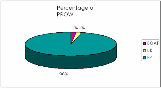
Byways open to all Traffic - Boat
A byway open to all traffic is a carriageway over which the PRoW enables vehicular traffic but one which is used primarily for the purposes for which footpaths and bridleways are used i.e on foot and on horseback.- there are 6 byways recorded on the DMS
- approximate distance of 1.1km
- they make up 2% of the network.
-
Bridleways
A bridleway is a way over which the PRoW is on foot and on horseback, leading a horse and possibly with an additional right to drive animals.- There are 3 bridleways recorded on the DMS,
- approximate distance of 1.0km
- they make up 2% of the network;
-
Footpaths
A public footpath is a way over which the PRoW is on foot only- There are 245 footpaths recorded on the DMS,
- approximate distance of 44.9km,
- they makes up 96% of the network.
Chart 1: Percentage of PROW
Whilst the Borough is well served with public footpaths, it is recognised that there are a limited number of bridleways. There are permissive routes available for horse riders, but due to the urban nature of the area, the creation of additional routes is challenging. This is discussed further in Section 6 (Evaluation).
A number of permissive footpaths exist which are not recorded on the DMS. This gives rise to the presumption that there are gaps within the formal network.
There are a number of designated cycle routes which are linked viathe road network. More routes are proposed through the Local Transport Plan (LTP2) and the strategy is discussed in Section 7.
See Appendix 2 for the map of cycle routes within the Borough of Southend-on-Sea.