Southend Central Area Action Plan & Proposals Map - Proposed Submission
1. Introduction
1.1 Background to this document
1. In accordance with Southend Borough Council’s adopted Local Development Scheme and the Strategic Objectives and policies within its Core Strategy Development Plan Document [DPD], the Borough Council is preparing an Area Action Plan [AAP] for the central area of the town to be known as Southend Central Area Action Plan (SCAAP) and associated Proposals Map.
2. This publication of submission version consultation, in accordance with Regulation 27 of the Town & Country Planning (Local Development) (England) (Amendment) Regulations, is a statutory stage in the preparation of the Southend Central AAP and enables representations to be made based on the document’s "soundness" and legal compliance. It is a spatial plan that will eventually form part of the statutory Local Development Framework for the Borough.
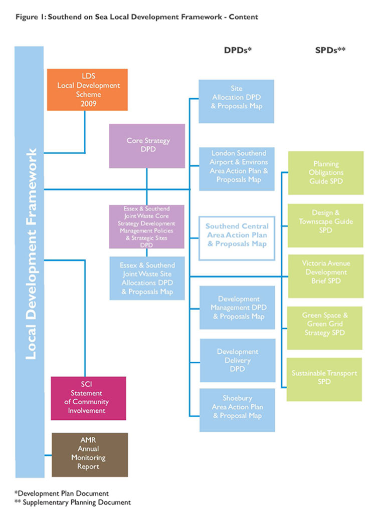
(9) 3. It builds on the Issues and Options version published in June 2010 It will set out the Borough Council's policies for positively managing development within the Southend Central AAP boundary which includes the Town Centre and Central Seafront Area and will be used to assess and determine planning applications in association with other Southend Local Development Framework documents. See Figure 1 Southend-on-Sea Local Development Framework - Content
4. The document will advise people who are considering development within the Southend Central AAP boundary on the nature of proposals that are likely to be acceptable. It also contains Proposal Site and Areas depicted on a Proposals Map where certain types of development are encouraged to assist with regeneration and growth of Southend.
1.2 The Consultation Process
5. The stages in the timetable for production of this Area Action Plan for the central area are as follows
|
Consultation Issues & Options Town Centre Area Action Plan and Seafront Area Action Plan (regulation 25) |
January 2007 |
|
Issues and Options consultation including preferred approach to Spatial Development Strategy [regulation 25] |
June/July 2010 |
|
Publication/Consultation [regulation 27] |
September/October 2011 |
|
Submission to the Secretary of State [regulation 30] |
March/April 2012 |
|
Target date for Examination |
July 2012 |
|
Proposed date for Adoption |
December 2012 |
1.3 What is an Area Action Plan?
6. An Area Action Plan is a development plan document that forms part of the Local Development Framework for the Borough. Such Plans are used when there is a need to provide the planning framework for areas where significant change or conservation is needed. Area Action Plans should:
- deliver planned growth areas;
- stimulate regeneration;
- protect areas particularly sensitive to change;
- resolve conflicting objectives in areas subject to development pressures; or
- focus the delivery of area based regeneration initiatives.
7. Area Action Plans can assist in producing a consensus as to the right strategy for an area and how it might be implemented. They can act as a focus and a catalyst for getting several key agencies and landowners to work together.
1.4 Why is an Area Action Plan required for Central Southend?
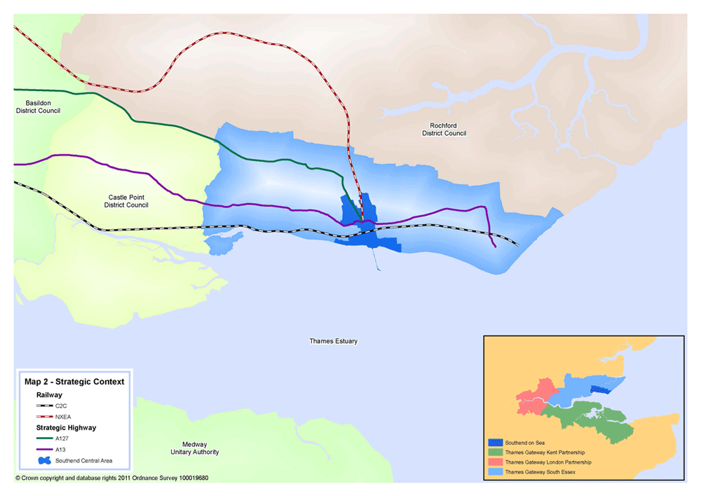
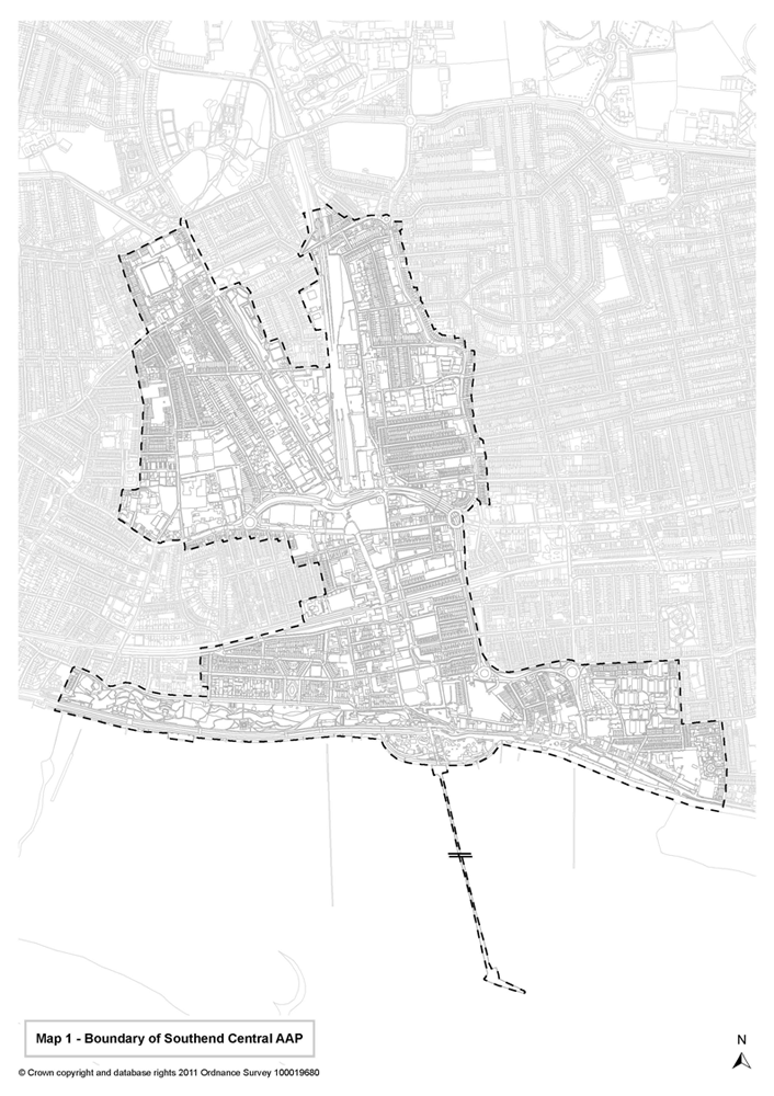
(1) 8. The Core Strategy DPD spatial strategy makes provision for a large share of the Borough’s new growth and regeneration to be focussed in the central area of the borough (see Map 1 – Boundary of Southend Central Area Action Plan). The purpose of this Plan, therefore, is to give more detailed consideration to how and where employment-led regeneration and growth can sustainably be accommodated in the Town Centre, Central Seafront Area and surrounding gateway neighbourhoods. The Plan contains detailed policies and site specific proposals aimed at strengthening and transforming Southend Town Centre’s sub-regional role as a successful retail and commercial destination, cultural hub and education centre of excellence, leisure and tourist attraction, and place to live (see Map 2 – Central Area Strategic Context). The intention is to also seek to safeguard, conserve and enhance the significant biodiversity, green space and other environmental resources in the area and on the foreshore.
LDF organogram
Map 1 - AAP Boundary
Map 2 - Strategic Context